Instruments
Passive Optical
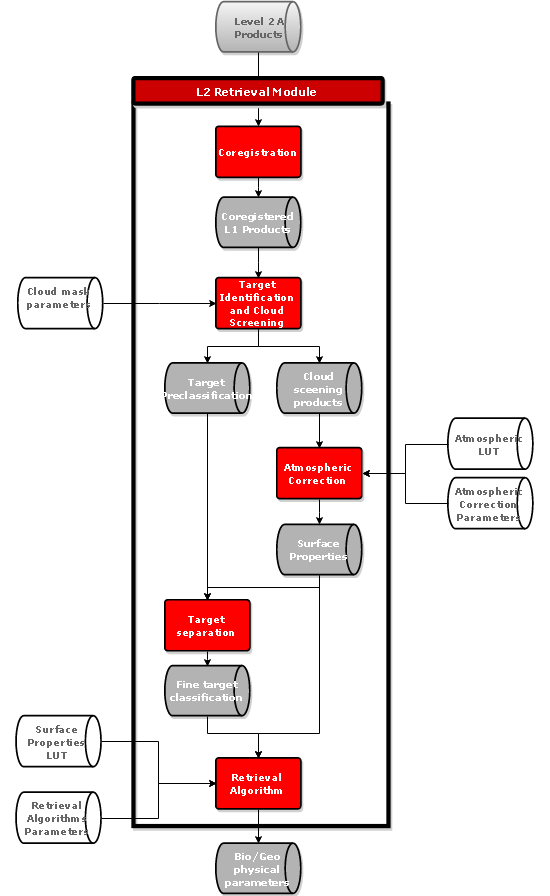
Level-2 Retrieval
The Level-2 Retrieval Module is in charge of performing the retrieval of the geophysical parameters that are objective of the mission/instrument. Depending on the mission and on its definition of the products, this module would generate level-2 data or products at higher level of processing. The simulation chain includes the following Blocks:
- The Coregistration Block is in charge of merging Level-1 products coming from different instruments/satellites so they can be combined for the retrieval of common Level-2 products
- The Target Identification Block is in charge of make a pre-classification of each image pixel. A cloud screening identifies those image pixels affected by clouds and the cloud properties. This is attached to the Level-2 products and is an input to the atmospheric correction
- The Atmospheric Correction retrieves the spectral surface properties (e.g. reflectance, emissivity, temperature)
- Target Separation Block performs a more precise pixel classification using the surface reflectance/temperatures in order to select the retrieval algorithm to be applied.
- The Retrieval Algorithms obtain the bio- and geo-physical characteristics (e.g., chlorophyll, surface temperature, ozone profile, fluorescence) from the retrieved surface properties or TOA radiance (for atmospheric limb measures).
The simulation flow for the L2 Retrieval Module is the following:
Biblos.COTS This is Biblos COTS package with installation script. Script installs libraries:- kissFFT- boost- netcdf- zlib- hdf5- eigen
Biblos.Commons This is a package common for all the Blocks and Modules. Commons contain helper functions e.g. for reading NetCDF or parsing XML files as well as Blocks and Modules interfaces.
Tool: Tiff to NetCDF converter BIBLOS works with NetCDF format for the images. This is a tool to convert Tiff to NetCDF. It is external to BIBLOS, the user shall convert the image offline. THe package includes an executable, a README file (with instructions) and an example auxiliary file.